Land sales from the public domain were recorded by field employees of the U.S. General Land Office, state and local officials, and clerks of the Illinois Central Railroad. These records were transferred to the Illinois State Archives for permanent retention in 1957. Because the records are arranged by legal description, a database was developed to allow the records to be searched by name.
The database contains information about nearly 550,000 land sales from the 54,740 square miles of the public domain sold within Illinois. Each purchase entry includes the purchaser's name, purchase date, number of acres, price per acre, numeric code indicating the county in which the land is located, legal description (township, section, range), volume and page numbers of original entry, and variously, the sale type, and the purchaser's sex and residence.
A good explanation of the system for mapping township sections is offered in the "Determining Location" topic located near the bottom of the Public Domain Land Tract Sales webpage at Illinois State Archives Illinois, some of which has been provided below.
![]()
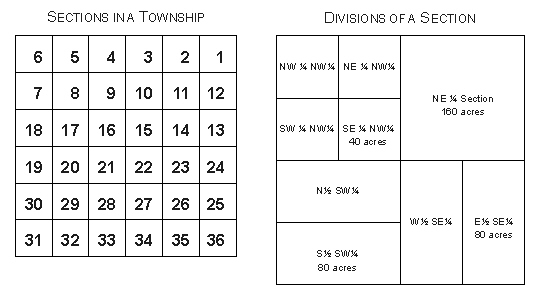
Typically, townships are divided into 36 sections of 640
acres. Each section is further subdivided into quarter sections,
half-quarter sections, or quarter-quarter sections. Examples of
these subdivisions within a township appear below.
NW – The northwest ¼ of a section (160 acres)
S2NW – South ½ of the northwest ¼ of a section (80 acres)
NENW – The northeast ¼ of the northwest ¼ of a section (40
acres)
| Cape Girardeau MO |
Union | |
 |
Pulaski | |
| Scott MO | Mississippi MO | Ballard KY |